URBAN DESIGN OF SELIMIYE MOSQUE
Edirne︎ 2010 ︎ Urban Design ︎ Çiğdem Mahsunlar, Tuğba Okçuoğlu, Hakan Deniz Özdemir, Sibel Özdoğan, Nevzat Sayın


One of the city's major issues is its road network. The road coming from Istanbul enters directly into the city, almost skimming the wall of the Old Mosque, and the chaotic road junction at this point creates congestion in the city center. The necessity to pass through the same point regardless of your destination causes real confusion. The habit of everyone coming to the city center to leave their car at the first place they find, coupled with the absence of any preventive measures, even prevents taking proper photographs of the unique structures.
Therefore, it is an inevitable reality that the first intervention must be the reorganization of the road network. Even a brief study of cities with similar sizes and topographic features provides ample clues about what needs to be done.
We believe the first decision should be to change the road entering directly into the city center so that it forms a ring around the city center. This intervention, which might seem very sharp and difficult, appears feasible based on on-site observations. The preference for short and finite roads leading to the city centre with the help of the main roads that will turn the heavy traffic into a ring and reach the destination point seems obvious.. Ensuring that all pedestrianized roads can be used by vehicles when necessary will remove obstacles to services like fire trucks, ambulances, and garbage collection.An inner ring to be reached from the outer ring and the roads extending from here to the centre are the basic rule of a hierarchical road pattern for vehicles.
Even if the uses that require intensive vehicle traffic from time to time such as industrial sites, university campuses, stations, bazaars, new bus stations, etc. are on easily accessible roads that are not slowed down, the roads outside these uses are arranged by targeting a slowed down vehicle traffic.
This arrangement has been considered in line with decisions about what the city should be or how it should be in the future, and it has been developed under the assumption that the slow city quality will be an important gain for Edirne. Although it may seem contradictory for a developing city, the "slowness" here is not an obstacle to development but a decision about the direction of development. Considering the total length of the outer ring is 9 km and the inner ring is 3.5 km, the road length to reach any desired point would be at most 1-2 km. The most significant benefit of this intervention is making being in the city center attractive for Edirne residents and encouraging visitors to stay in the city.
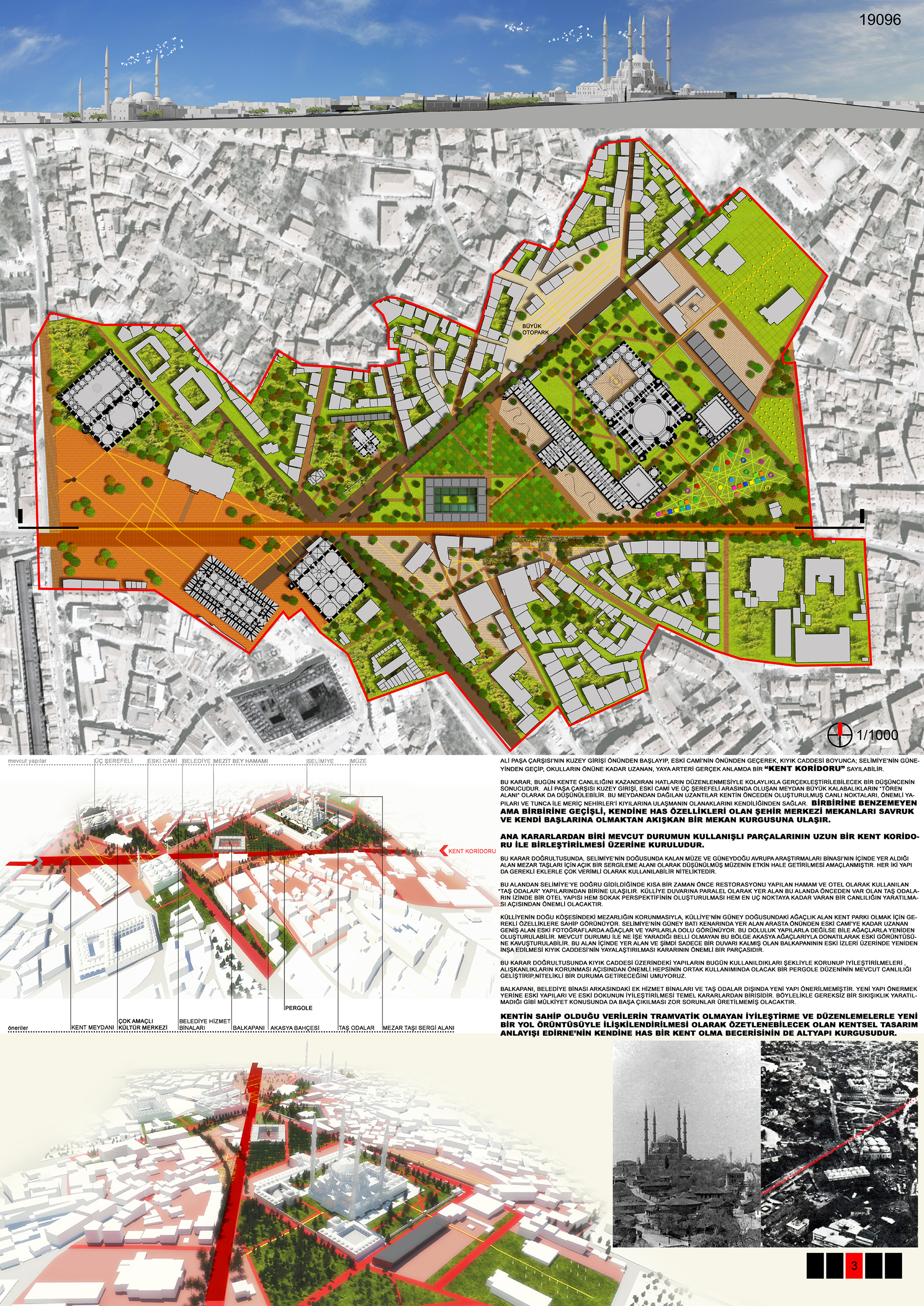
The pedestrian artery starting in front of the northern entrance of Ali Pasha Bazaar, passing in front of the Old Mosque, and extending along Kıyık Street; passing south of Selimiye and reaching up to the schools, can be considered a genuine "urban corridor.”
This decision results from a thought easily realizable by organizing the lines that give vitality to the city today. The square formed between the northern entrance of Ali Pasha Bazaar, the Old Mosque, and Üç Şerefeli could also be considered a "ceremonial area" for large crowds. The extensions radiating from this square naturally provide access to the city's previously established lively points, important structures, and the banks of the Tunca and Meriç rivers. The city center spaces, each with unique characteristics but interconnected and flowing, transform from scattered and isolated to a fluid spatial arrangement.
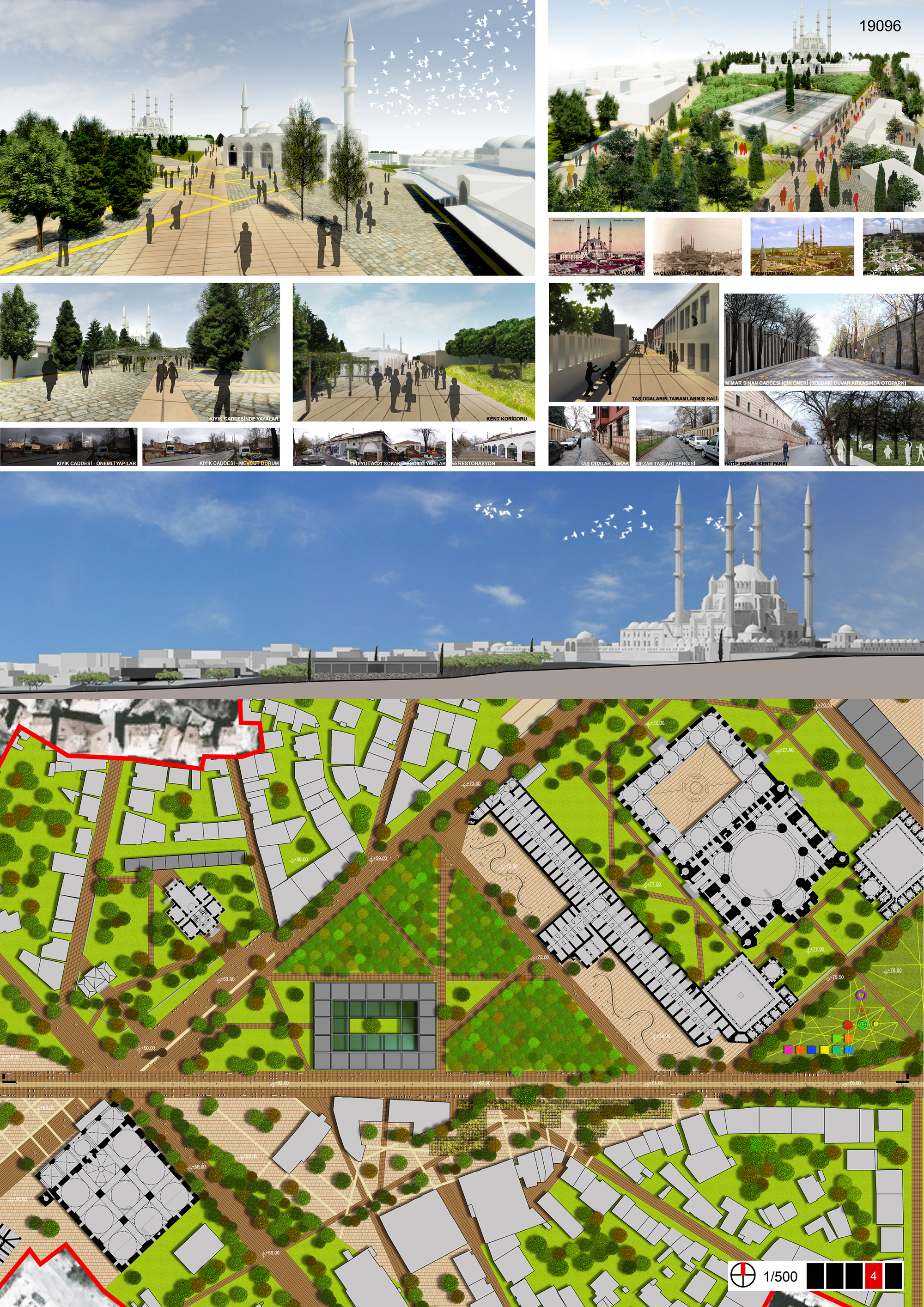
One of the main decisions is based on combining the useful parts of the existing situation with a long urban corridor. Accordingly, the area east of Selimiye, including the museum and the Southeast European Research Building, is envisioned as an open exhibition area for tombstones, with the aim of making the museum active. Both structures can be used very efficiently with necessary additions.
When heading towards Selimiye from this area, one reaches the recently restored bath and the "stone rooms" buildings used as a hotel. A hotel structure along the path of the previously existing stone rooms in this area, parallel to the complex wall, will be significant for creating a street perspective and fostering liveliness up to the farthest point. With the preservation of the cemetery at the eastern corner of the complex, the wooded area to the south-east of the complex seems to have the necessary characteristics to become an urban park.
The wide area extending from the front of the arasta on the south-western edge of Selimiye to the Old Mosque appears filled with trees and buildings in old photographs. This density can be recreated with trees, if not with buildings. This area, which is not clear what it is used for in its current state, can be arranged with acacia trees and restored to its former appearance. Reconstructing the honey storage building on its old traces within this area is an important part of the decision to pedestrianize Kıyık Street. Maintaining and improving the buildings on Kıyık Street as they are used today is important for preserving habits. We hope that a pergola arrangement for their common use will enhance the existing liveliness and elevate it to a more qualified condition.
Apart from the honey storage building, additional service buildings behind the municipal building, stone rooms, and pergolas, no new structures are proposed. One of the fundamental decisions is to improve old buildings and the existing fabric instead of proposing new structures. This approach prevents unnecessary congestion and avoids difficult-to-manage issues related to property ownership. The urban design approach, which can be summarized as associating the city's data with non-traumatic improvements and arrangements in a new road network, also forms the infrastructure for Edirne's capability to be a unique city.

Except for Balkapanı, additional service buildings behind the municipality building, stone rooms and pergola, no new buildings are proposed. One of the main decisions is to improve the old buildings and the old texture instead of proposing new buildings. This approach prevents unnecessary congestion and avoids difficult-to-manage issues related to property ownership. The urban design approach, which can be summarised as the association of the city's data with a new road pattern through non-tramatic improvements and arrangements, is also the infrastructure fiction of Edirne's ability to be a unique city.